NASA and India have teamed up to launch a satellite that will map the Earth and track even the smallest changes in the land surface and ice.
The $1.3 billion (£980 million) mission will help forecasters and rescue workers prepare in advance for floods, landslides, volcanic eruptions and other disasters, researchers say.
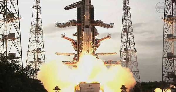
The satellite was launched from India and will repeatedly scan almost the entire surface of our planet. Two radars – one in the US and one in India – will operate around the clock, penetrating clouds, rain and foliage, collecting extensive data in high detail.
Microwave signals coming to Earth from these two radars will be reflected back to the satellite's huge antenna reflector, which sits at the end of a boom resembling a beach umbrella.
Scientists will analyze incoming and outgoing signals as the spacecraft flies over the same regions twice every 12 days, detecting changes as small as fractions of an inch.
“This is a first-of-its-kind, groundbreaking radar satellite that will change the way we study our planet and help us better predict natural disasters before they happen,” said NASA's mission director Nikki Fox before the launch.
Ms Fox led a small NASA delegation to India to attend the launch.
It will take a week to unfold the satellite's 9-metre boom and deploy its 11.5-metre-diameter drum reflector made of gold-plated wire mesh. Science operations are expected to begin by the end of October.

Among the satellite's key measurements are: the melting of glaciers and polar ice sheets; changes in groundwater supplies; movement and stress on the Earth's surface that contribute to landslides and earthquakes; and changes in forest and wetland cover that lead to increased emissions of carbon dioxide and methane.
Nasa will provide $1.2bn (£900m) for the three-year mission, which will see the company provide low-frequency radar and a reflector.
The Indian Space Research Organisation's $91m (£68m) share includes the high-frequency radar and key satellite structures, as well as the launch from a barrier island in the Bay of Bengal. It is the two countries' biggest space collaboration.
The Nisar satellite (short for Nasa-Isro Synthetic Aperture Radar) will operate for about
Sourse: breakingnews.ie