The city of Boston is bracing for record flooding as a powerful nor’easter storm is intensifying off the coast Friday. The National Weather Service is forecasting 3 to 4 feet of coastal flooding for the New England coast, along with 60+ mph wind gusts expected to snap power lines and a punishing mix of rain and snow. Further south along the East Coast, the storm is bringing heavy snow, winds, and rain. And thousands of flights have been canceled.
Here’s the latest coastal flood advisory from the National Weather Service.
It will be a “very dangerous situation” for many in New England, the NWS states. “This [is] an extreme weather event,” the NWS’s Boston office advised earlier Friday. “Many neighborhoods will likely become isolated [by flooding], some for extended periods of time.” The service is also warning about “extreme beach erosion” and possible breaches of protective sand dunes along the shore.
And photos from the area prove it. Here’s the scene in Watertown, Massachusetts, just a few miles from Boston.
And here’s a man demonstrating three-plus feet of flooding in Marshfield, Massachusetts.
Be sure to check out the National Weather Services’ Boston office on Twitter for updates. I also keep this Twitter list of meteorologists handy for up-to-the-minute updates on severe weather events.
In short: It’s an awful start the first weekend to March for New Englanders! And the culprit is a common mid-winter storm: the nor’easter. Here’s what we know about them.
Nor’Easters, explained
Nor’easters are named after their winds, which blow from the Northeast. They’re a common storm during the winter and early spring months along the Atlantic Coast of the US. You may recall, earlier in January, the Northeast was hit by a powerful nor’easter which left much of the coast blanketed in snow. (In the press, the storm was called the “bomb cyclone.”)
Many of the historic blizzards on the East Coast — the blizzard of 1996, the “Snowzilla” of 2016 — are the result of nor’easters.
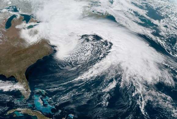
So what do they look like? Here’s a handy photo. It’s a satellite image of the January “bomb cyclone,” which meteorologists say is a near-textbook image of a nor’easter storm.


Though these storms often spin in a cyclone pattern like hurricanes (counter-clockwise) — and look like hurricanes in satellite imagery — they are not hurricanes. Hurricanes get their strength from warm ocean waters. Nor’easters are the result of the fact that, during the winter and early spring months, air temperatures over the land are often colder than air temperatures over the ocean.
This set up “makes the East Coast a prime breeding ground for storms like this,” Jeff Frame, an atmospheric scientist at the University of Illinois at Urbana-Champaign, told me during the “bomb cyclone” in January.
When the cold air mass meets the warmer air mass, Frame explains, an area of low pressure forms at their boundary. That’s what always happens when air flows from areas of high pressure to areas of low pressure.
That’s what’s happening in the picture above. The lowest pressure is found in the eye of the storm, with the air spinning counterclockwise as it rushes into the center. This movement generates the energy for the ferocious winds found in the storm.
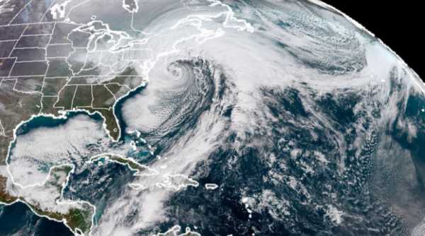
And that’s what’s happening in this satellite imagery captured today:
Why does it spin counterclockwise? The simple answer: Because the Earth is rotating beneath it. The more complicated answer: Areas closer to the equator actually rotate faster than areas closer to the poles. (Kind of like how you need to run faster in the outside of a track to keep up with someone running in the inside lane.)
It’s this asymmetry that nudges the winds to spin in the counter-clockwise direction. Bonus points if you remember from high school Earth science that this is called the “Coriolis effect.”
When the pressure of the storm drops more than 24 millibars in 24 hours, meteorologists say the storm is undergoing “bombogenesis,” which is just a fancy way of saying the storm is intensifying rapidly. (Other types of storms can undergo “bombogenesis” too.)
Nor’easters may ruin weekends. But they are essential mechanisms by which heat is redistributed around the globe, Frame explains. In the image above, you can see how warm tropical air is pulled northward, like a conveyor belt, to mix with colder air in the north. Without these storms, the tropics would grow even hotter and the poles even colder. They make it so we can have pleasant, mild temperatures throughout much of the globe.
Sourse: vox.com