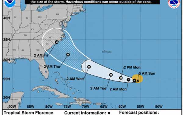
Following a period of rapid intensification over the past 24 hours, Hurricane Florence is headed toward the US East Coast and is expected to become an extremely dangerous Category 4 level storm by Monday.
Interaction with a smaller storm and the semi-permanent Bermuda High system will drive not only wind speeds and heavy rains, but is predicted to increase the size of the storm.
Coastal US residents from Florida to Massachusetts are watching the progress of Florence closely, as landfall is not precisely known at this point.
Additional atmospheric influences could cause the hurricane to come to a halt over a single area, dumping crushingly large amounts of water in an event similar to last year’s cataclysmic flooding of Houston, Texas, in the wake of Hurricane Harvey.
National Oceanic and Atmospheric Administration (NOAA) aircraft passing through Florence on Sunday morning noted winds of 85 mph and rising on the surface, while barometric pressure is 975 mb and falling fast.
Heavy surf and heavy rain is predicted up and down the coast, however the location of Hurricane Florence’s landfall will be the deciding factor in which low-lying coastal areas to evacuate.
Sourse: sputniknews.com


