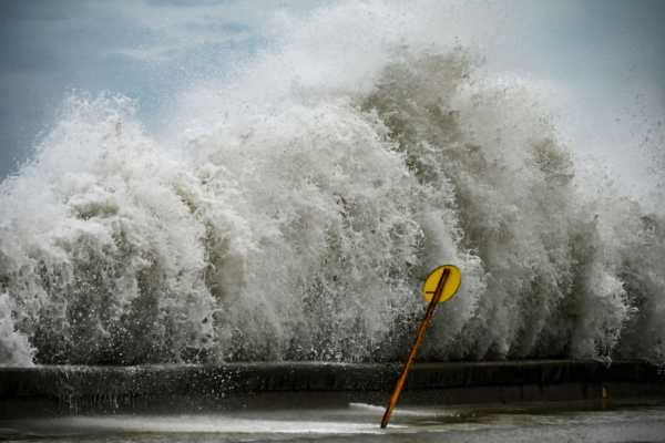
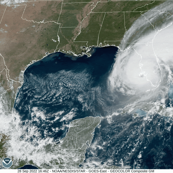
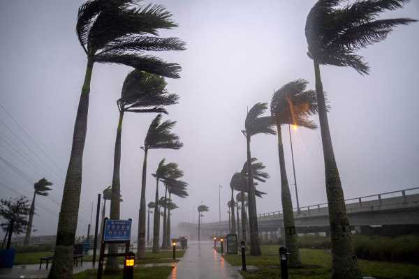
On Monday morning, Hurricane Ian had wind speeds of 75 miles per hour. Just 48 hours later, those speeds had more than doubled. On Wednesday, as the storm made landfall in southwestern Florida, Ian’s wind hit 155 mph — just shy of a Category 5 storm, the most severe category for a hurricane.
Such rapid growth is known by meteorologists as “rapid intensification.” It’s defined as storms whose wind speeds increase by roughly 35 mph or more in less than 24 hours. “Ian definitely met that criteria,” said Paul Miller, a professor of oceanography and coastal sciences at Louisiana State University.
While wind speed isn’t the only force that makes storms dangerous, hurricanes that rapidly intensify are especially worrisome. They can easily catch coastal communities off guard, giving them little time to prepare, Miller said.
So how did Ian get so big, so fast?


It’s an important question, as storms like this one are highly destructive and are likely to become more frequent in the years to come.
What made Hurricane Ian strengthen so quickly
There are three main ingredients that, when mixed together, can result in a rapidly intensifying hurricane: moist air, low wind shear (wind coming from different directions or at different speeds), and warm ocean water.
“All three of those things create a favorable ecosystem for a hurricane to establish circulation and intensify,” Miller said.
Ian had them all. As it developed several days ago, the storm system faced some disrupting winds, but there was little shear as it grew over the last few days, Miller said. And Ian has largely avoided a region of dry air in the Gulf of Mexico. (Had Ian hit Florida farther north, it might have deteriorated faster, he said.)
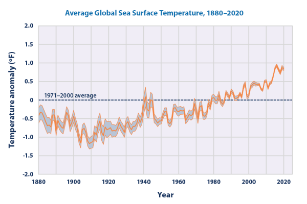
Then there’s the warm ocean water. The Gulf of Mexico has been unseasonably warm this summer, according to the National Weather Service. And climate change is heating the Caribbean ocean by a little over 1 degree C (1.8 degrees Fahrenheit) per century.
“Even small changes — half a degree C, or a degree — can really make a big difference,” said Brian McNoldy, a hurricane researcher at the University of Miami.
Another reason why the ocean is so warm is that it’s been a relatively quiet hurricane season so far. As hurricanes churn through the Caribbean, they sap heat from the water and churn it up, making it colder and less favorable for rapid intensification, Miller said.
“We’ve been able to let the Gulf sit and bake throughout hurricane season,” Miller said. “We haven’t had another storm yet this season to go through and cool off the Gulf through that mechanism. There’s this pristine Gulf of Mexico from a sea-surface temperature standpoint, and Hurricane Ian has been able to exploit that.”
Rapidly intensifying storms are hard to predict, and thus hard to prepare for
Forecasters have made big strides in figuring out where hurricanes will go. Storm track predictions that could only be made 24 hours in advance 20 years ago can now be issued 72 hours ahead.
But it’s been tougher to anticipate how strong storms will get. (Case in point: As of Sunday night, Ian was forecasted to peak at 130 mph).
What do you think of Vox? Tell us!
We want to get to know you better — and learn what your needs are. Take Vox’s survey here.
That’s because there are so many factors that influence the intensity of a storm, and they can change rapidly over time and space. Recall that rapid intensification occurs when hurricanes pass over areas with calm, warm waters. But it isn’t just how warm the ocean is at the surface; how deep the heat goes matters too. Measuring the depth of warm water and predicting sea surface conditions can be tricky. Often it requires hurricane hunter aircraft to drop temperature sensors into the ocean ahead of the storm.
With a limited view of a hurricane’s potential intensity, it’s more difficult to issue warnings and evacuation orders.
That happened last summer when Hurricane Ida galloped toward Louisiana. The storm jumped from Category 2 strength to Category 4, with winds topping 150 mph, in less than a day. The sudden speed-up left little time to coordinate the logistics to get people out of the path of the storm.
“We didn’t have the time with Ida to safely call for a mandatory evacuation where we would be putting over a million people on the road,” Collin Arnold, director of New Orleans Homeland Security and Emergency Management told WVUE Fox 8 last year.
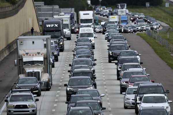
Now it’s happening again with Hurricane Ian. In some parts of Florida, “It’s no longer possible to safely evacuate,” said Florida Gov. Ron DeSantis on Wednesday. “It’s time to hunker down and prepare for this storm.”
So predicting a storm’s intensity isn’t just an academic exercise, but a lifesaving tool. Better forecasts are part of why fewer people are dying in extreme weather events, even as those events become more destructive.
But people also have to heed forecasts. And a hurricane’s impact doesn’t end when the storm blows itself out. Flooding can last for days, and as Puerto Rico has shown after Hurricane Fiona swept through last week, power outages can linger, compromising access to food, lighting, and clean drinking water. Floridians thus won’t be out of danger when the winds die down and the water recedes; they’re vulnerable at least until the lights come back on.
Is climate change causing storms to grow faster?
If climate change is warming the ocean, and warm oceans fuel storms like Ian, does that mean climate change is making storms grow more quickly? Possibly.
According to a recent analysis of hurricane data by the Associated Press, there were about 25 percent more rapidly intensifying storms in the Atlantic Ocean and Eastern Pacific in the last 10 years compared to 40 years ago. Some past scientific studies have also shown that hurricanes are intensifying more rapidly in parts of the Atlantic in recent years.
“As the oceans warm a little bit, you’re just gradually making [rapid intensification] more likely,” McNoldy said.
Global warming could also help rapidly intensify storms in another way: Climate change tends to warm the land faster than the sea, forming a temperature gradient along coasts, said Karthik Balaguru, a climate scientist at the Pacific Northwest National Lab. That gradient tends to favor rapid intensification of hurricanes along the Atlantic Coast, he said.
But it’s worth bearing in mind that intensification is a complicated process, Miller said. And other factors that affect these events (wind shear and air moisture) aren’t clearly linked to climate change, he said.
“No one has 100 percent figured it out,” McNoldy said of intensification.
Our goal this month
Now is not the time for paywalls. Now is the time to point out what’s hidden in plain sight (for instance, the hundreds of election deniers on ballots across the country), clearly explain the answers to voters’ questions, and give people the tools they need to be active participants in America’s democracy. Reader gifts help keep our well-sourced, research-driven explanatory journalism free for everyone. By the end of September, we’re aiming to add 5,000 new financial contributors to our community of Vox supporters. Will you help us reach our goal by making a gift today?
Sourse: vox.com