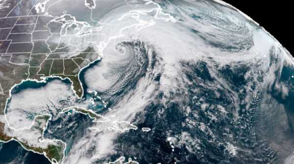
The fourth nor’easter storm in three weeks was pummeling the Northeast Wednesday, bringing an all-too-familiar mix of snow, sleet, and misery from Washington, DC, through much of New England. Happy second day of spring.
Some areas may see more than a foot of snow. (Meanwhile, a wholly different weather system, an atmospheric river, is dumping punishing rain over the West Coast. It’s a bad weather day on the coasts of these United States.)
While it is somewhat rare to see so many nor’easter storms in a row, they are not uncommon for this time of year and this part of the country.
And even though these storms bring blizzards and are a menace, they do play a critical role in regulating the climate on Earth. Here’s what we know about nor’easters. (For storm updates and warnings, follow the National Weather Service’s Boston office on Twitter.)
Nor’easters, explained
Nor’easters are named after their winds, which blow from the northeast. They’re a common storm during the winter and early spring months along the Atlantic coast of the US. You may recall, earlier in January, the Northeast was hit by a powerful nor’easter that left much of the coast blanketed in snow. (In the press, the storm was called the “bomb cyclone.”)
Many of the historic blizzards on the East Coast — the blizzard of 1996, the “Snowzilla” of 2016 — are the result of nor’easters.
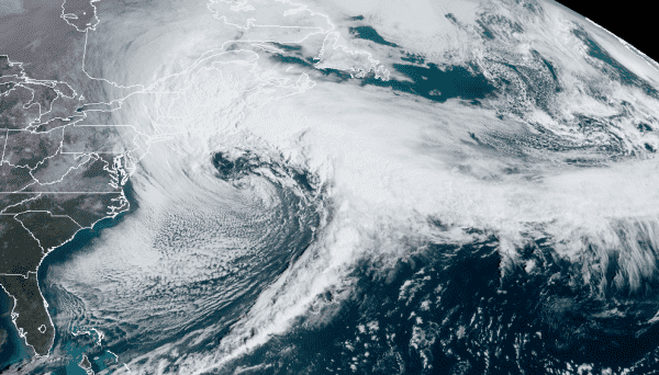
So what do they look like? Here’s a handy photo. It’s a satellite image of the January “bomb cyclone,” which meteorologists say is a near-textbook image of a nor’easter.


Though these storms often spin in a cyclone pattern like hurricanes (counterclockwise) and look like hurricanes in satellite imagery, they are not hurricanes. Hurricanes get their strength from warm ocean waters. Nor’easters are the result of the fact that during the winter and early spring months, air temperatures over the land are often colder than air temperatures over the ocean.
This setup “makes the East Coast a prime breeding ground for storms like this,” Jeff Frame, an atmospheric scientist at the University of Illinois at Urbana-Champaign, told me during the “bomb cyclone” in January.
When the cold air mass meets the warmer air mass, Frame explains, an area of low pressure forms at their boundary. That’s what always happens when air flows from areas of high pressure to areas of low pressure.
That’s what’s happening in the picture above. The lowest pressure is found in the eye of the storm, with the air spinning counterclockwise as it rushes into the center. This movement generates the energy for the ferocious winds found in the storm.
This shape was seen in the past three recent nor’easters.
Why four of these storms have appeared in the span of a month is complicated. Andrew Freedman at Mashable has a great, detailed explanation. But basically: The jet stream (the river of airflow that directs weather systems in the Northern Hemisphere) has been in position to energize and direct storms to the northeastern US. And there’s a weather pattern over Greenland that’s preventing these storms from simply moving out to sea.
As with any weather event, attributing these four storms to climate change is hard. But there are some studies that suggest that as the Arctic warms, more extreme and cold winter weather in the US will become more prevalent. And the Arctic just finished one of the warmest, least icy winters on record. And perhaps that’s what we’re seeing here.
Why do they spin counterclockwise?
The simple answer: because the Earth is rotating beneath it. The more complicated answer: Areas closer to the equator actually rotate faster than areas closer to the poles. (Kind of like how you need to run faster on the outside of a track to keep up with someone running in the inside lane.)
It’s this asymmetry that nudges the winds to spin in the counterclockwise direction. Bonus points if you remember from high school earth science that this is called the “Coriolis effect.”
When the pressure of the storm drops more than 24 millibars in 24 hours, meteorologists say the storm is undergoing “bombogenesis,” which is just a fancy way of saying the storm is intensifying rapidly. (Other types of storms can undergo bombogenesis too.)
Nor’easters may inundate whole states with snow. But they are essential mechanisms by which heat is redistributed around the globe, Frame explains. In the image above, you can see how warm tropical air is pulled northward, like a conveyor belt, to mix with colder air in the north. Without these storms, the tropics would grow even hotter and the poles even colder. They make it so we can have pleasant, mild temperatures throughout much of the globe.
Sourse: vox.com