Several factors put Idalia on track to rival damage from previous deadly hurricanes.
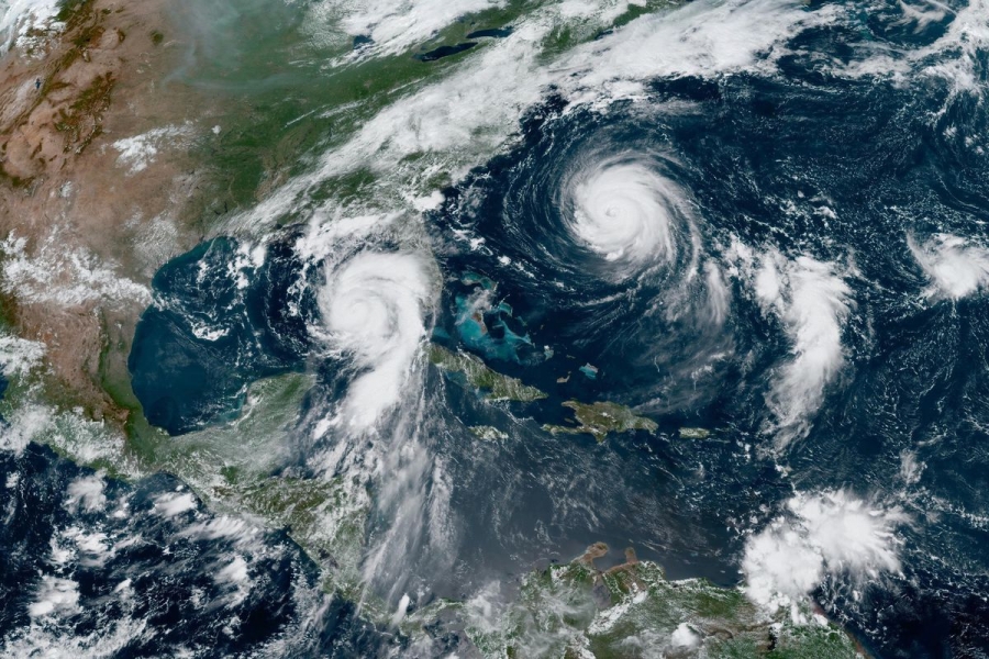
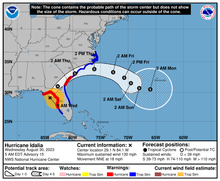
Hurricane Idalia made landfall in Florida on Wednesday morning as a dangerous Category 3 storm with wind speeds of 125 miles per hour. Meteorologists are projecting severe impacts along Florida’s Gulf Coast: storm surges of up to 16 feet, several inches of rainfall, and possibly tornadoes. The National Hurricane Center is warning Idalia will bring “catastrophic impacts” and “destructive life-threatening winds.”
The potential impacts from Idalia are certainly frightening, but they’re not all that surprising. This region of the world has all the ingredients for a powerful, dangerous, expensive, and destructive hurricane, from extremely warm ocean temperatures that fuel tropical storms to growing coastal populations that are vulnerable to storm surges. And unfortunately, some of these ingredients are becoming more potent as average temperatures rise.
Here’s what could turn Idalia into one of the year’s most dangerous storms.
Idalia churned over unusually warm ocean water on its path to Florida
If there’s one thing a hurricane needs to grow, it’s warm ocean water. And this summer, the Gulf of Mexico and the broader Caribbean have been extremely and anomalously warm. In late July, a buoy off the coast of Florida registered 101.1 degrees Fahrenheit, which is about as warm as the water in a hot tub.
As Hurricane Idalia moved north from Cuba toward Florida’s Big Bend region on the Gulf Coast — where the Panhandle meets the peninsula — it passed over water that’s still unusually hot. Check out the chart below, which shows sea-surface temperature anomalies, measured in Celsius. Darker red indicates regions that are warmer than average.
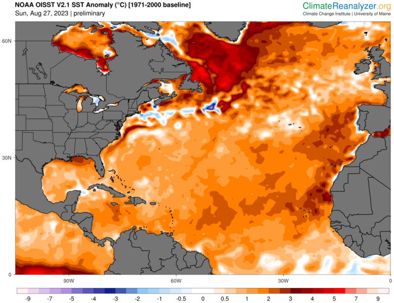
Water in the path of the storm was roughly 1 to 3.5 degrees Fahrenheit warmer than average temperatures this time of year. That provided fuel for Idalia to go through what’s called rapid intensification, which is when a storm’s wind speeds increase by roughly 35 mph or more in less than 24 hours.
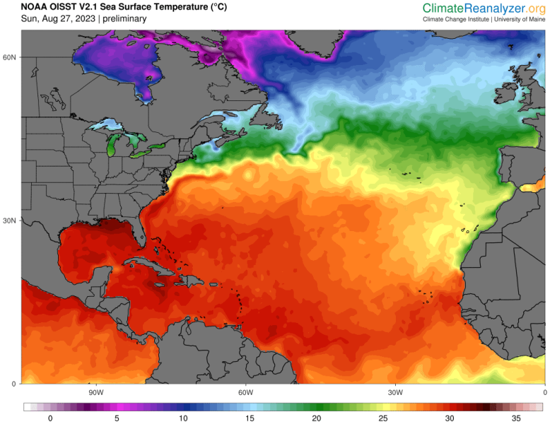
The chart below shows, more simply, how hot the Atlantic is as of a few days ago. Waters around Tampa, just south of the storm’s center of impact, are currently in the high 80s, according to the National Oceanic and Atmospheric Administration (NOAA).
One complicating factor: The world is in an El Niño year, a climate phenomenon that refers to the warm phase of the Pacific Ocean’s temperature cycle.
On the one hand, El Niño tends to raise global temperatures. On the other, it usually increases wind shear in the North Atlantic, which can prevent hurricanes from forming. While these forces usually counteract each other to an extent, resulting in an average hurricane season, this year has been so hot that the scales have been nudged in favor of more storms. Earlier this month, forecasters updated their outlook to “an above-normal level of activity” for hurricanes.
The hurricane is pushing a huge amount of water inland
When a hurricane rams the coast, it usually pushes water inland, causing what’s known as storm surge. It’s often the deadliest part of tropical storms.
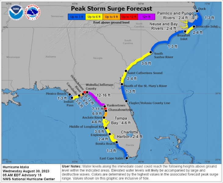
That’s a major concern with Idalia. Even a few feet of storm surge can sweep away vehicles, yet current forecasts show parts of the Gulf Coast getting surge as high as 16 feet above ground level. This torrent of water can knock out critical infrastructure, inundate roads, spread disease, and cause injuries. And in low-lying areas like Florida’s Gulf Coast, that water can linger for days.
Worsening the threat, the forecasted landfall of Idalia lines up with Tampa Bay’s highest tides of the month, meaning even more water could surge inland.
The Florida Forgotten Coast and Big Bend are some of the most surge-prone areas in the world. The terrain is essentially flat inland a long way from the coast. The NHC’s storm surge maps for a category 4 hurricane show the potential for 6-9+ feet of surge 10 miles inland. #Idalia pic.twitter.com/eroXuswtfD
— Clark Evans (@ClarkEvansWx) August 29, 2023
Idalia is striking an area still recovering from another storm
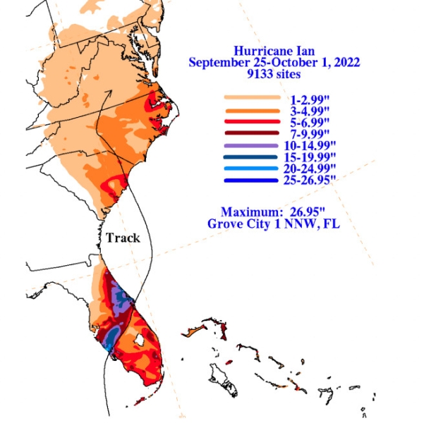
Hurricane Ian, which struck Florida last year, became the deadliest storm in the state since 1935, killing at least 149 people. It landed on Florida’s Gulf Coast at Category 4 strength and drove a storm surge as high as 18 feet; the surge alone was blamed for 41 deaths. The storm also dumped more than 25 inches of rain in some areas, only adding to the flooding.
Hurricane Ian was remarkably destructive, too, damaging more than 52,000 structures. The storm’s price tag ultimately amounted to an estimated $109 billion, making it the costliest hurricane in Florida history.
The damage displaced a number of residents who have still not returned home, and many Floridians are still waiting for insurance payouts. Some areas, meanwhile, are still clearing debris, while others are filled with buildings waiting to be demolished.
Now Idalia is threatening a similar region. Although the eye of the storm will make landfall north of where Ian struck, the zone of impact will at least partially overlap with Ian’s, compounding the impacts of the prior storm.
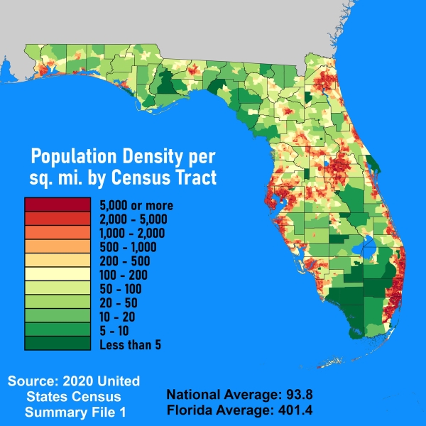
Florida’s population is highest in its most vulnerable areas
More than three-quarters of people in Florida live along the coast. Coastal regions also have some of the fastest growth rates in the state. Between 2010 and 2020, the Tampa-St. Petersburg area grew by more than 365,000 people, according to the Florida Department of Transportation.
This means that as Idalia makes landfall, more people and property will be in the path of destruction.
Update, August 30, 7:50 am ET: This story was originally published on August 29 and has been updated with new information about Hurricane Idalia’s location and strength.
Source: vox.com