Back-to-back atmospheric rivers have triggered floods, snowstorms, and power outages in the Golden State.
Umair Irfan is a correspondent at Vox writing about climate change, Covid-19, and energy policy. Irfan is also a regular contributor to the radio program Science Friday. Prior to Vox, he was a reporter for ClimateWire at E&E News.
A brutal winter storm is battering the West Coast with torrential downpours in the south, blizzards in the north, and winds gusting up to 160 miles per hour.
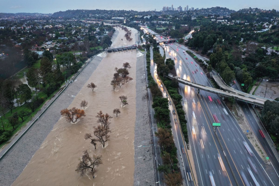
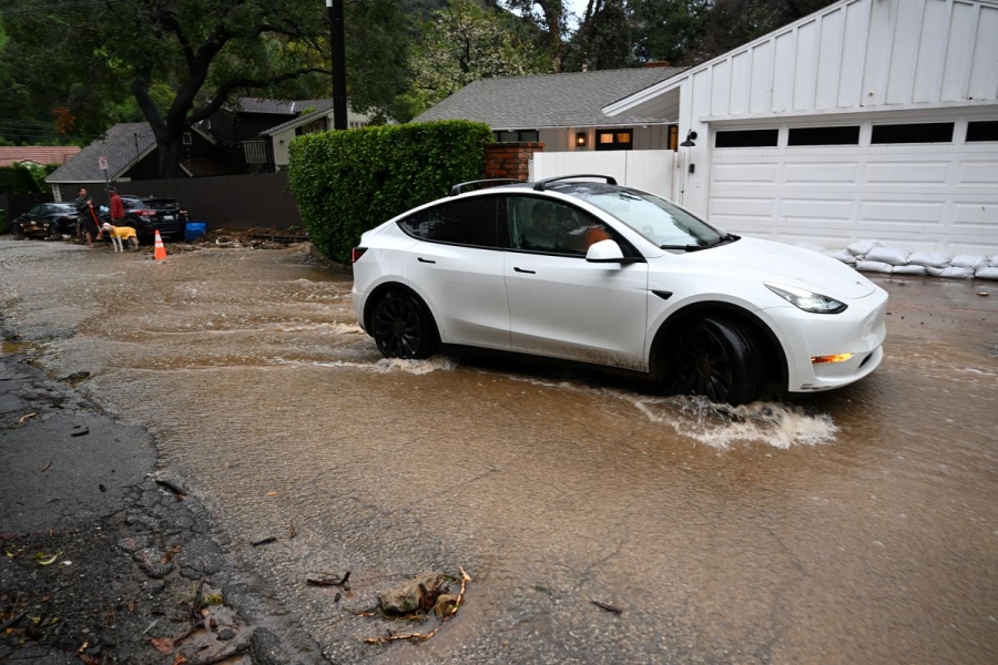
The severe weather has killed at least three people. California Gov. Gavin Newsom declared a state of emergency on Sunday for eight counties in the southern part of the state. The 14 million residents of the region are facing a high risk of excessive rainfall. Further north, more than 150,000 electricity customers lost power as of Tuesday morning.
And more severe weather is in store: The National Weather Service reports heavy rain will continue in parts of California through at least Wednesday, fueling “locally catastrophic flash and urban flooding” in cities like Los Angeles while snow will create “whiteout conditions and near impossible travel above 5,000 feet” in the Sierra Nevada mountains.
Concerning radar view this afternoon across the Los Angeles metro as a stalled band of rain from persistent #AtmosphericRiver continues to re-intensify, w/widespread heavy rain now falling once again across nearly entire LA Basin. Renewed flooding/mudslides likely. #CAwx #LArain https://t.co/NEibzVplfr pic.twitter.com/4INUzOlm4z
— Dr. Daniel Swain (@Weather_West) February 5, 2024
The wet, wintry weather is a part of a phenomenon called an atmospheric river. This is a gargantuan channel of moisture in the sky, up to 375 miles wide, bearing as much as 15 times the amount of water flowing at the mouth of the Mississippi River. As it courses above the ocean and makes landfall, the moist air rises, cools, condenses, and drops enormous quantities of precipitation.
Californians are all too familiar with these airborne rivers. Just over a year ago, another series of atmospheric rivers also soaked the Golden State, triggering floods, mudslides, and power outages.
This particular river is a bit different, however. It’s a variety known as a Pineapple Express because it originated near Hawaii. And it’s especially fierce because of the strong ongoing El Niño warming pattern in the Pacific Ocean, adding more water to the storm.
These downpours are just the latest in a series of strange, extreme weather events to hit the West Coast. Hurricane Hilary in the Pacific Ocean last year triggered southern California’s first ever tropical storm watch, followed by a late-season record-breaking heat wave. The region as a whole is still recovering from a decades-long drought that pushed essential water supplies to the brink of depletion. In fact, states like California have been lurching between drought and deluge in recent years, a phenomenon dubbed weather whiplash.
And as the climate warms, the likelihood and severity of some of these events are poised to increase.
Why atmospheric rivers can be such a threat — and why they won’t necessarily solve the West’s water problems
Atmospheric rivers are a regular event, though they often aren’t anywhere near as intense as the storms hitting the West Coast at the moment.
In California, a few fall and winter atmospheric rivers can provide upward of half of the state’s annual precipitation. It’s an essential mechanism for filling aquifers, building up snowpack to nourish rivers throughout the year, and quenching thirsty metropolises and farmland.
The difficulty with huge atmospheric rivers is that they dispatch more water at once than ecosystems and water managers can store or put to use. Though precipitation can vary drastically in the Western US, and people are keen to store what they can, much of the water right now is running back into the ocean rather than being saved in reservoirs or aquifers. Water reservoirs in California are on average at 116 percent of their capacity at the moment, and some are releasing water to make room for more rain.
Sudden, severe downpours also overwhelm sewer and drainage systems in cities, leading to flooding.
WATCH: Los Angeles areas are submerged as heavy rain from an atmospheric river causes flooding. pic.twitter.com/vMkk5fOLt6
— The Weather Channel (@weatherchannel) February 1, 2024
In rural areas, years of drought have led soils in some places to dry out and condense, so they can’t absorb water as quickly as soils that have received more regular moisture. That can then contribute to flash floods and mudslides under heavy rain. Years of drought, wildfire, erosion, and development have also denuded the West of critical vegetation that would ordinarily serve to absorb and slow the flow of rainwater.
Slowing the flow of water is also important for recharging groundwater stores, allowing time for surface water to trickle underground. In California, groundwater provides 40 percent of the state’s water in typical years and 60 percent in drought years. Currently, about one-third of monitoring wells show above normal levels of groundwater, and one-third are below normal.
Meanwhile, the Sierra Nevada snowpack — which provides 30 percent of California’s water on average — is more than 25 percent below the average for this time of year. Though the recent storms have helped top up stores, the snow drought could persist into the spring.
At the same time, there’s no guarantee that there will be adequate precipitation through the rest of the year, so a summer drought is still possible. A wet winter followed by a hot dry summer can also be a recipe for wildfires as plants rapidly drink up the bountiful rain, grow, and then desiccate in the heat, turning into kindling.
El Niño is amplifying these effects. As the surface of the Pacific Ocean heats up, more water evaporates, and as air gets hotter, it can hold onto more moisture. These combined effects lead to more frequent and intense atmospheric rivers.
Californians are adapting to extreme weather, but the risk is growing
The good news is that forecasting has improved, allowing meteorologists to issue alerts and warnings days in advance so people can prepare or evacuate. Early warnings are a major reason why many types of weather disasters are killing far fewer people. Scientists were able to anticipate this atmospheric river more than a week ago.
CW3E AR Update: The active weather over the USWC is forecast to continue into early February as this sequence of #AtmosphericRiver over the Pacific brings more precipitation to the region. Check out our latest forecast outlook here: https://t.co/YxYzoqwUVf pic.twitter.com/8JKmcNRs9H
— CW3E Scripps (@CW3E_Scripps) January 24, 2024
Residents are also working to mitigate many of the worst effects of these storms. Water managers are implementing new water conservation tactics and incentives so they’re less vulnerable to shortfalls. There are also new flood control projects underway, including new reservoirs, levees, pumping stations, and floodplain restoration.
However, the goalposts are still moving. Climate change is powering up these storms even further. Rising average temperatures are driving more extreme rainfall events and could lead to more atmospheric rivers as the planet heats up further.
And with populations and property growing in some vulnerable areas, the damage from these storms is poised to become more costly as well. In addition, warmer winters are bringing more rain than snow, and snowpack is melting earlier in the season, adding to the West’s water woes.
So while people can adapt to an extent, there’s no substitute for addressing the root causes of climate change: the emissions of greenhouse gases from burning fossil fuels.
Source: vox.com