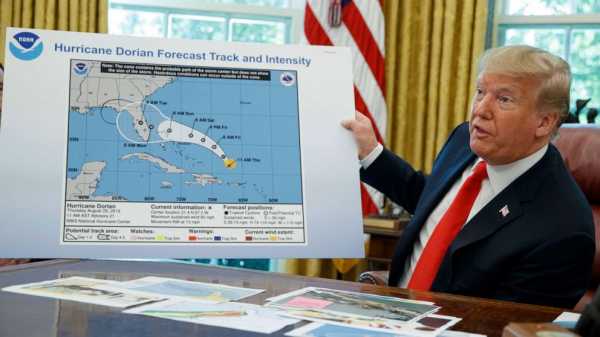
“No, I just know, yeah. I know that Alabama was in the original forecast,” he said. “They thought it would get it, as a piece of it, it was supposed to go — Actually we have a better map of that which is going to be presented, where we had many lines going directly — many models, each line being a model. And they were going directly through. And in all cases, Alabama was hit. If not likely, in some cases pretty hard. Georgia and Alabama, it was a different route. They actually gave that a 95 percent chance probability,” he said.
“That map that you showed us today, looked like it almost had, like, a Sharpie written on it,” a reporter said during a second White House event on Wednesday.
Trump cut off the reporter and said, “I don’t know. I don’t know. I don’t know.” He also said the map had been from three or four days before, when it had actually been issued six days earlier.
White House deputy press secretary Hogan Gidley tweeted Wednesday night that the line was, in fact, from a black Sharpie, and he criticized the media for focusing on it.
Late Wednesday, Trump did tweet an additional map displaying raw data — an “ensemble” of different computer models, and variations of those models, that meteorologists use to formulate a forecast.
“This was the originally projected path of the Hurricane in its early stages,” the president wrote. “As you can see, almost all models predicted it to go through Florida also hitting Georgia and Alabama.”
But the map he shared did not actually show any sort of actual projected path or official forecast — just the raw data — and government meteorologists never drew the conclusion that the storm would hit Alabama.
It is against federal law to knowingly issue or publish any counterfeit weather forecasts that falsely represent an official forecast issued by government entities like the National Weather Service and National Hurricane Center.
(MORE: Hurricane Dorian shutters airports in Florida, Carolinas: See the latest closures )
Spokespeople for the Federal Emergency Management Agency and the National Oceanic and Atmospheric Administration, which oversees the National Weather Service and the National Hurricane Center, referred questions on whether the map was doctored to the White House. The White House did not respond to multiple requests for comment.
At one point last Friday, one forecast map did show a cone that brushed the Alabama-Florida border, but it did not go nearly as far.
Sourse: abcnews.go.com