Harry Kane has won individual plaudits but it is a team trophy he craves – and what the Bayern Munich fans expect. The club’s former striker Claudio Pizarro provides insight into the demands ahead of the title showdown with Bayer Leverkusen…

Image: Harry Kane has taken the Bundesliga by storm but if Bayern Munich do not deliver the title then the mood will change
Harry Kane is already a hero at Bayern Munich. From shaking hands with all 300 members of staff at the club’s base to embracing Oktoberfest and meeting sundry supporter groups, Bavaria has fallen for Kane as surely as those beaten Bundesliga defences.
His 24 goals in the competition is the most by any player in history after 20 games and puts him on course to win the European Golden Shoe for the first time in his career. Even Robert Lewandowski’s Bundesliga record of 41 goals in a season is at risk.
Kane has the most goals from open play and the most goals from set plays. He has the most goals with his head and the most goals with his feet. Bayern are accustomed to dominating games but nobody has scored more goals than Kane on the counter-attack.

Highlights as Kane scores his 24th Bundesliga goal of the season for Bayern
From his goal on his Bundesliga debut to his hat-trick against Borussia Dortmund, the first player to do that for Bayern in his first game against them, it has been a spectacular start. Easy to argue now that this was inevitable but it is impressive how quickly he has adjusted.
“It is different,” says Claudio Pizarro, the former Bayern Munich striker. “But he adapted pretty well and pretty fast,” he adds with a smile. “He is an excellent player. Everybody knew that. But it is sometimes not so easy to make this change.”
He continues: “I think he has a good connection with the players, with the city, with the coaches. And he is scoring goals. That is the most important for a striker. He has a lot of confidence from the first game. When you get that, you can score many goals.”

Image: Kane is the top scorer in the Bundesliga
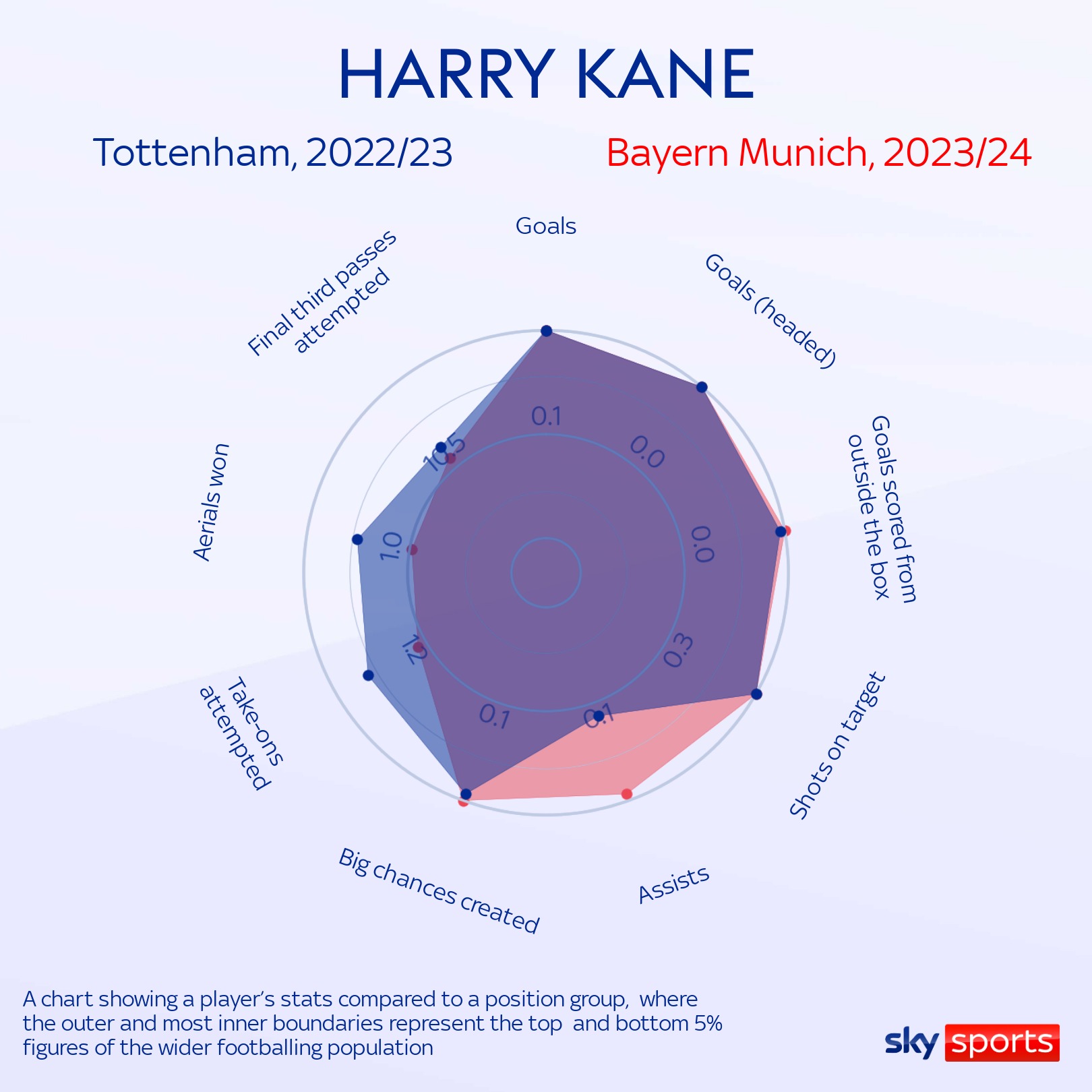
Of course, with Kane it is about more than the goals. Indeed, comparing his output at Tottenham last season to his numbers for Bayern, it is the number of goals that he is creating for others that stands out. He already has eight assists in all competitions.
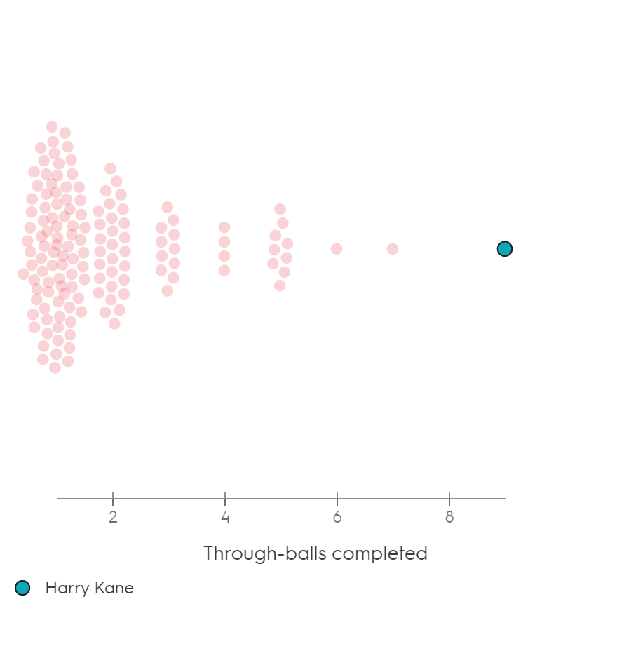
Lewandowski’s goal record might fall but his assist tally that season surely will. Kane has so far completed more through-balls than any other player in the Bundesliga. Leroy Sane has provided five assists for him but he has returned the favour on three occasions.

“He needs players like that,” says Pizarro. And then, there is the defensive contribution to consider as well. “He is helping the team in every way. Sometimes you can see him in his own box defending situations and five minutes after that he is scoring a goal.”
His reputation is already elevated, a new audience appreciating his talents. Kane has never finished higher than 10th in the Ballon d’Or voting – even when top scoring at a World Cup. For comparison, Jamie Vardy finished eighth in 2016. In 2023, Kane only scraped into the top 20. Expect success at Bayern to change that.
But these individual prizes are not what Kane is chasing in Munich. It is team trophies that he craves and it is team trophies that Bayern demand. These final months of the season will dictate how the acquisition of the Bundesliga’s most expensive player will be judged.
Bayern visit Bayer Leverkusen on Saturday knowing that defeat would see them fall five points behind the league leaders. Against an opponent that has not yet lost this season, that would risk surrendering the Bundesliga title for the first time in over a decade.
The onus is on Kane. He was signed to score goals but he was signed to score important goals too. Hat-tricks in a 7-0 home win against Bochum and against nine-player Darmstadt are welcome but Bayern expects. Pizarro knows that after nine seasons with Bayern.
“It is very difficult and there is a lot of pressure,” explains the Peruvian, who scored 100 goals for the club. “When I came to Bayern in 2001 for the first time after I left Bremen, I came there and it was, like, wow, there is a lot of pressure on this team.
“In time you learn to deal with that. And, of course, Harry Kane is a very experienced player. He knows exactly what to do and how to deal with the pressure. At some point, you get used to it and you deliver many better things when you are living with this pressure.”

Kane annoyed some Spurs supporters when he made some of these observations himself soon after his arrival. He pointed out that “it was not a disaster” if the London club went a couple of games without winning. At Bayern, there was a different feeling.
He could feel the anxiety when the club won 4-0 and 3-1 in their first two Bundesliga games of the season and questions were being asked about the manner of the victories. Thomas Tuchel’s team have lost twice this term and the manager is under scrutiny.
“It is part of coaching Bayern Munich,” says Pizarro.
“It is always like that. Even when you are doing a great job in some competitions, if you are not there in every competition sometimes there is a lot of criticism from the press or the board or the fans. It is not that easy to do that job there.”
- Stream Sky Sports with NOW | Get Sky Sports
It is not easy being a Bayern striker either. Chances come, goals flow and praise follows. But expectations are vast and, as absurd as it might seem, that means Kane must deliver against Leverkusen or risk his signing being seen as emblematic of a Bayern misstep.
He stepped up with his three goals in Dortmund. Now, Tuchel and Bayern need him again. “If Bayern win, the situation is going to be a lot easier for the players and for everyone. It is going to be crucial to decide who is going to win the Bundesliga,” says Pizarro.
“This game is going to decide many, many things.”
Including how Kane’s first season at Bayern is remembered.
Watch Bayer Leverkusen vs Bayern Munich live on Sky Sports Football on Saturday; kick-off 5.30pm
Sourse: skysports.com