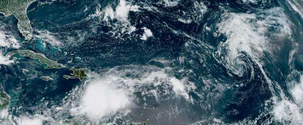
SAN JUAN, Puerto Rico — Authorities in the Dominican Republic prepared to shut down the country on Tuesday as Tropical Storm Franklin took aim at the island of Hispaniola that it shares with Haiti and threatened to unleash landslides and heavy floods.
The storm on Tuesday morning was located about 260 miles (420 kilometers) south of Santo Domingo, the capital of the Dominican Republic. It had maximum sustained winds of 50 mph (85 kph) and was moving west at 3 mph (5 kph).
Franklin was forecast to make a sharp turn north on Tuesday and then strengthen before making landfall early Wednesday in Hispaniola. It is expected to linger on top of the island for a day before exiting to open water on Thursday, according to the National Hurricane Center in Miami.
Dominican officials announced they would close schools, government offices and businesses by midday Tuesday and reopen them on Thursday. They also noted that the heavy rainfall forecast would not be a problem for the country’s multiple dams since water levels were low.
Nearly half of the Dominican Republic’s 31 provinces were under red alert as the storm approached, with the Public Works Ministry announcing that it dispatched 3,000 workers to 14 provinces to prepare for Franklin.
The storm is forecast to drop up to 10 inches (25 centimeters) of rain in both countries, with up to 15 inches (38 centimeters) in isolated areas. Heavy rainfall is of great concern to Haiti, where severe erosion in many places often leads to dangerous flooding. More than 40 people died in June following a day of heavy rain from a thunderstorm.
A tropical storm warning was in effect for the entire southern coast of the Dominican Republic and Haiti. A tropical storm watch was posted for the Turks and Caicos Islands.
Meanwhile, a tropical depression in the Gulf of Mexico strengthened overnight to become Tropical Storm Harold and was expected to hit the southern coast of Texas later Tuesday. It had maximum sustained winds of 45 mph (75 kph) and could strengthen further before making landfall.
A tropical storm warning is in place for the area between the mouth of the Rio Grande and Port O’Connor, meaning tropical storm conditions are expected within 12 hours. The National Hurricane Center predicted “scattered instances of flash flooding” on land and “life-threatening surf and rip-current conditions” at the coast.
On Aug. 10, the National Ocean and Atmospheric Administration updated its forecast and warned that this year’s hurricane season would be above normal.
Between 14 to 21 named storms are forecast. Of those, six to 11 could become hurricanes, with two to five of them possibly becoming major hurricanes, the NOAA said.
The Atlantic hurricane season runs from June 1 to Nov. 30.
Sourse: abcnews.go.com